Introducing Geography
What is geography? Put simply, geography is the study of the evolving character and organization of the Earth’s surface. It is about how, why, and where human and natural activities occur and how these activities are interconnected.
What makes geography different from other disciplines? Geography adopts a unique set of perspectives to analyze the world and its human and natural phenomena. These perspectives include the spatial viewpoint of geographers, the interest of geographers in the synthesis of ideas across the boundaries of conventional studies, and geographers’ usage of tools to represent and manipulate spatial information and spatial phenomena. Figure I.1 shows these perspectives in the form of a cube with each perspective displayed on a different face.

The first unique perspective of geography is its spatial viewpoint. Geographers are interested not only in how something happens, but also where it happens and how it is related to other happenings nearby and far away. The spatial viewpoint can focus at three levels. At the place level, geographers study how processes are integrated at a single location or within a single region. For example, an urban geographer may study the spatial structure of a particular city—how and where neighborhoods and commercial centers develop and take on their unique characteristics. Or a physical geographer may study the ecology, climate, and soils of a national park. At the space level, geographers look at how places are interdependent. An economic geographer may examine how flows of goods, information, or money connect cities and towns that are of different sizes and at different distances apart. Or a physical geographer may map the sources of sediment flowing into a river and chart their downstream effects. Geographers also look at human and natural activities at different scales, sometimes zooming in for a close look at something small or pulling back for an overview of something large. Often what looks important at one scale is less important at another.
The second perspective of geography is synthesis. Geographers are very interested in putting ideas together from different fields and assembling them in new ways—a process called synthesis. Of particular interest to geographers are studies that link conventional areas of study. In physical geography, for example, a biogeographer may investigate how streamside vegetation affects the flood flow of rivers, thus merging the physical geography subfields of ecology and hydrology. A human geographer may study how economic innovation—developing new kinds of goods and services—varies from region to region according to cultural and legal factors, thus merging the human geography subfields of economics, politics, and sociology. The many connections between environmental processes and human activities are also subjects of geographic synthesis. For example, a classic study area in geography is perception of hazards—why do people build houses next to rivers or beaches when it is only a matter of time before floods or storms will wash their homes away? Here, geographers study the interaction of hydrology with perception and cognitive learning.
The third perspective of geography is geographic representation. Here, geographers develop and perfect tools for representing and manipulating information spatially. Cartography —the art and science of making and drawing maps—is a subfield of geography that focuses on visual display of spatial relationships. Visual display also includes remote sensing—acquiring images of the Earth from aircraft or spacecraft and enhancing them to better display spatial information. Verbal descriptions use the power of words to explain or evoke geographic phenomena. Mathematical and statistical models predict how a phenomenon of interest varies over space and through time. Geographic information systems store, manipulate, and display spatial information in very flexible ways. Cognitive representation refers to spatial relationships as they are stored in the human brain—mental mapping of real space into the subjective space that people experience. Taken together, the perspectives of viewpoint, synthesis, and representation define geography as a unique discipline that focuses on how the natural and human patterns of the Earth’s physical and cultural landscape change and interact in space and time.
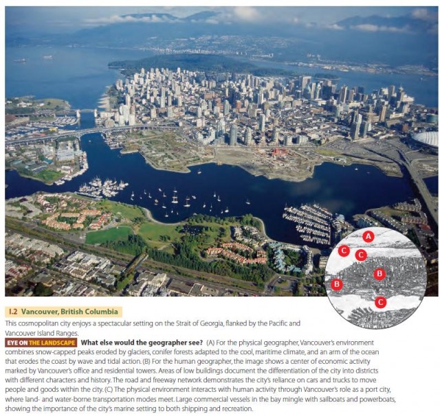
Another way to illustrate geographic perspectives is by an example—Vancouver, British Columbia, illustrated in Figure I.2. The image, a visual display, shows a place, the central city of Vancouver, set in the space of the Strait of Georgia and Pacific and Vancouver Island Ranges and imaged at a local scale. In the geographer’s view, Vancouver is a unique landscape shaped by both environmental and human processes and their interactions.

HUMAN AND PHYSICAL GEOGRAPHY
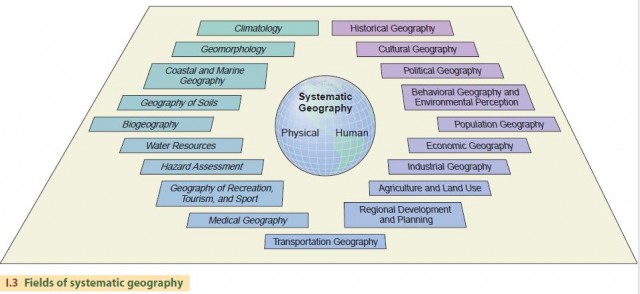
Like many other areas of study, geography can be regarded as having a number of subfields, each with a different focus but often overlapping and interlocking with other subfields. We can organize these subfields into two broad realms—human geography, which deals with social, economic and behavioral processes that differentiate places, and physical geography, which examines the natural processes occurring at the Earth’s surface that provide the physical setting for human activities. Figure I.3 is a diagram showing the principal fields of physical and human geography. Reading downward from the left, we see five fields of physical geography, from climatology to biogeography. These topics are the main focus of this text.

Climatology is the science that describes and explains the variability in space and time of the heat and moisture states of the Earth’s surface, especially its land surfaces. Since heat and moisture states are part of what we call weather, we can think of climate as a description of average weather and its variation at places around the world. Chapters 1–7 will familiarize you with the essentials of climatology, including the processes that control the weather we experience daily. Climatology is also concerned with climate change, both past and future. One of the most rapidly expanding and challenging areas of climatology is global climate modeling, which we touch on in several chapters. This field attempts to predict how human activities, such as converting land from forest to agriculture or releasing CO2 from fossil fuel burning, will change global climate.
Geomorphology is the science of Earth surface processes and landforms. The Earth’s surface is constantly being altered under the combined influence of human and natural factors. The work of gravity in the collapse and movement of Earth materials, as well as the work of flowing water, blowing wind, breaking waves, and moving ice, acts to remove and transport soil and rock and to sculpt a surface that is constantly being renewed through volcanic and tectonic activity. The closing chapters of our book (Chapters 12–17) describe these geomorphic processes, while the basic geologic processes that provide the raw material are covered in Chapters 11–12. Modern geomorphology also focuses on modeling landform-shaping processes to predict both short-term, rapid changes, such as landslides, floods, or coastal storm erosion, and long-term, slower changes, such as soil erosion in agricultural areas or as a result of strip mining.
The field of coastal and marine geography combines the study of geomorphic processes that shape shores and coastlines with their application to coastal development and marine resource utilization. Chapter 16 describes these processes and provides some perspectives on problems of human occupation of the coastal zone.
Geography of soils includes the study of the distribution of soil types and properties and the processes of soil formation. It is related to both geomorphic processes of rock breakup and weathering, and to biological processes of growth, activity, and decay of organisms living in the soil (Chapter 10). Since both geomorphic and biologic processes are influenced by the surface temperature and availability of moisture, broad-scale soil patterns are often related to climate.
Biogeography, covered in Chapters 8 and 9, is the study of the distributions of organisms at varying spatial and temporal scales, as well as the processes that produce these distribution patterns. Local distributions of plants and animals typically depend on the suitability of the habitat that supports them. In this application, biogeography is closely aligned with ecology, which is the study of the relationship between organisms and environment. Over broader scales and time periods, the migration, evolution, and extinction of plants and animals are key processes that determine their spatial distribution patterns. Thus, biogeographers often seek to reconstruct past patterns of plant and animal communities from fossil evidence of various kinds. Biodiversity— the assessment of biological diversity from the perspective of maintaining the diversity of life and life-forms on Earth—is a biogeographic topic of increasing importance as human impact on the environment continues. The present global-scale distribution of life-forms as the great biomes of the Earth provides a basic context for biodiversity.
In addition to these five main fields of physical geography, two others are strongly involved with applications of physical geography—water resources and hazards assessment. Water resources is a broad field that couples basic study of the location, distribution, and movement of water, for example, in river systems or as ground water, with the utilization and quality of water for human use. This field involves many aspects of human geography, including regional development and planning, political geography, and agriculture and land use. We touch on water resources briefly in this book by discussing water wells, dams, and water quality in Chapters 14 and 15.
Hazards assessment is another field that blends physical and human geography. What are the risks of living next to a river, and how do inhabitants perceive those risks? What is the role of government in protecting citizens from floods or assisting them in recovery from flood damages? Answering questions such as these requires not only knowledge of how physical systems work, but also how humans perceive and interact with their physical environment as both individuals and as societies. In this text, we develop an understanding of the physical processes of floods, earthquakes, landslides, and other disaster-causing natural events as a background for appreciating hazards to humans and their activities.
Many of the remaining fields of human geography have linkages with physical geography. For example, climatic and biogeographic factors may determine the spread of disease-carrying mosquitoes (medical geography). Mountain barriers may isolate populations and increase the cost of transporting goods from one place to another (cultural geography, transportation geography). Unique landforms and landscapes may be destinations for tourism (geography of recreation, tourism, and sport). Nearly all human activities take place in a physical environment that varies in space and time, so the physical processes that we examine in this text provide a background useful for further learning in any of geography’s fields.
- physical geography
- What Climates and Weather Would Occur Here?
- How Does the Climate System Sustain Life?
- How Do We Use Computers to Study Climate Change?
- What Are the Consequences of Climate Change?
- What Factors Influence Climate Change?
- What Is the Evidence for Climate Change?
- How Does Air Quality Relate to Climate?
- What Causes Subarctic and Polar Climates?