Physical Landscapes
Three major landform regions divide Chile: the Andes Mountains, the coast and islands, and the Central Valley. The regions run north to south and parallel to each other. The Andes region is an awesome mountain barrier. Its majestic peaks of spectacular height and bone-chilling temperatures define the country's eastern border. The nation's coast includes imposing sea cliffs, beautiful beaches, low mountains, ice-scoured valleys, and sparsely settled islands. Squeezed between the Andes and the coast is a long Central Valley. Although Chile is a narrow country, its broad stretch of latitude embraces a variety of climates, ranging from a parched north, a temperate middle, and an extremely wet south. Spread over this crazy quilt geography is a variety of soils, plants, and animals.
THE ANDES
The high mountain range of the Andes (Cordillera de Los Andes in Spanish) extends like a backbone through the entire length of Chile, separating it from Argentina and Bolivia. Chile's northern Andes are an extension of the Bolivian altiplano (Spanish for “high plain”). The altiplano is between 11,000 and 13,000 feet (3,350 to 4,000 meters) in elevation. Cold winds are incessant, and they howl as they blow across the almost featureless plain. The evenness of the general surface is dramatic. Isaiah Bowman was the first U.S. geographer to explore the region. Writing in the early 1900s, he reported that the high plain looked “as if it were cut by a knife drawn along the edge of a ruler.” Bowman aptly noted that the surface is not entirely flat. A scattering of cone-shaped volcanoes, lava flows, and mountain ridges rise above the altiplano's generally level surface, reaching 17,000 feet (5,600 meters) in some places.
Farther south is Chile's central Andes region. This area has some of the highest peaks in the world. Mount Aconcagua, the highest summit (22,832 feet or 6,959 meters) in the Western Hemisphere is just across the border in Argentina. Several other prominent peaks are nearby. Together, these summits form one of the most spectacular landscapes in Andean South America. Yet, like forbidden fruit, the inviting summits have dangers, such as landslides, avalanches, earthquakes, and volcanic eruptions. Moreover, the heights endanger aircraft. Before the arrival of passenger jets in the 1960s, pilots, unable to fly above the mountains, had to wait for good weather and find a route between peaks.
The peril of Andean aviation was made famous when, in 1972, a vintage propeller-driven plane carrying rugby players from Uruguay crashed while attempting to fly across the Andes to Santiago, Chile. Some of those aboard died, but others survived the crash and for more than two months struggled against bitter-cold temperatures before being rescued. A book and a film titled Alive! immortalize this tragic story.
South of the central Andes, summits average about 6,500 feet (2,000 meters), much lower than the northern and central Andes. Geographers call the southern mountains the Patagonian Andes, because the mountains are not much higher than Argentina's adjoining Patagonia Plateau. Summits are low in part because of glacial erosion. During the Ice Age, erosion was widespread.
Ice fields (Campos de Hielos in Spanish) covered some mountain ridges completely. The ice slowly whittled down summits by plucking and scraping away rock. Today, only two ice fields exist, but they account for nearly 60 percent of the region's total ice surface. Outlet glaciers from the ice fields and smaller valley glaciers grow down the mountains to the ocean's edge, where they calve (break off) to form small icebergs.
The Andes Mountains are youthful because they are still growing. Collisions of sections of Earth's lithosphere (outer rock layer) are causing the mountains to build up. (Geologists call these “colliding sections plates.”) The collision involves a large, westward-moving South American plate and three plates that are moving eastward. Gravity is pulling the smaller, heavier plates beneath the South American plate, where they melt to form magma (molten rock). The collision is also causing the western edge of South America to compress, uplift, and fold to create the Andes Mountains. The magma beneath the continent rises to the surface during explosive volcanic eruptions.
Chile ranks fifth among nations in the number of active volcanoes. (Geologists define active volcanoes as those that have erupted within recent centuries.) Chile has 36 active volcanoes; it is behind Russia (52) and ahead of Iceland (18). The country's main volcanoes are south of the latitude of Santiago and include Cerro Azul, Llaima, Villarrica, and Cerro Hudson. Villarrica, which is east of Puerto Montt in southern Chile, is the most active volcano in South America. It has been erupting fitfully since the early 1980s. This peak is also Chile's deadliest volcano. Eruptions in 1949, 1963, 1964, and 1971 caused mudflows that killed 75 people. Fortunately, this is a relatively small number of deaths compared with those caused by volcanoes in other regions of the world.
Chile's landscape also experiences severe earthquakes caused by the strains of plate collision. Indeed, the coastal cities of Valparaiso, Concepcion, Valdivia, and Puerto Montt have been leveled or severely shaken by earthquakes in the past 100 years. One of the strongest temblors (earthquakes) of the twentieth century struck in Chile on May 22, 1960. The earthquake created a deadly tsunami (a superstrong ocean wave) that traveled across the Pacific Ocean to Asia in just 24 hours. The earthquake and tsunami killed more than 2,000 people in Chile, Hawaii, Japan, and the Philippines. Because of the unrelenting pressure from colliding plates, Chile will continue to experience severe quakes.
Human use of the Chilean Andes varies among its subregions, depending on available resources. In the northern altiplano region, the land is used in the summer to graze livestock. In the winter, tourists take jeep excursions there. The principle economic value of the northern Andes is its water supply for towns in the region. Chile's central and southern Andes offer outdoor enthusiasts many pastimes.
Alpine scenery, trout-filled lakes and streams, and snow-covered slopes attract thousands of visitors each year. They come to camp, fish, hike, climb, and ride horses and mountain bikes. Whitewater rafting, water skiing, snow skiing, snow-boarding, and paragliding are also popular. Chileans also depend on the Andes' natural resources. Melted water from snow and ice feeds turbulent rivers. Hydroelectric dams on several of these rivers not only provide electricity, but also supply water to the nation's farmers, homes, and industries. Logging companies harvest the forests for their timber.
COAST AND ISLANDS
Chile and the other Andean countries have an emergent coastline. As the western edge of South America rises out of the sea, erosion and deposition by waves create narrow coastal plains, sea cliffs, headlands, small beaches, and marine terraces. The coastal plains are usually narrow, averaging less than 1 mile (1.6 kilometers) wide. Where there is no plain, ocean and land engage in a spirited battle. The unrelenting waves inevitably cut wall-like sea cliffs into the land. Areas that are more resistant to wave erosion become cliff-edged headlands (sections of land that jut into the sea). Waves focus most of their rage on the headlands. Between the promontories (land projecting into a body of water), relatively calm waters deposit narrow, curving strips of sandy beaches.
Over time, the relentless waves cut into the land to create wave-planed submarine benches (flat areas). The benches become a stair-step series of marine terraces (terrazas fluviornaritias) above the water's edge, as plate convergence gradually forces them out of the sea. Some of these terraces, such as Antofagasta and Tocopilla in northern Chile, are large enough for coastal settlements. There are only a few good deepwater harbors. They are all situated in valley openings that have protection from storms.
Chile's southern coastline begins south of Puerto Montt. During the Ice Age, glaciers grew out of the southern Andes. Wrestward-moving tongues of ice gouged huge depressions in the Central Valley and coast range. After the Ice Age ended, about 10,000 years ago, glaciers worldwide melted. The glacial melt water poured into ocean basins to raise sea level to its present height. Along Chile's southern coast range, areas that were not eroded by the ice became a forest-covered chain of islands (archipelago). Ocean water filled the icescoured Central Valley, and narrow arms of the sea (fjords) flooded into the glaciated valleys of the Andes. The rugged, broken shoreline of Chile's south bears a strong similarity to other glaciated mountainous coastlines, such as those of Norway and western Canada.
Chile's coast range (cordillera de la Costa) rises abruptly from the shoreline. The range consists of a narrow, leveltopped plateau. Elevations are greatest in the central area that separates Santiago from Valparaiso, but heights never exceed 6,500 feet (2,000 meters). The north to south trending range gradually decreases in elevation from the central area to less than 3,280 feet (1,000 meters) at both ends. The northern end is at the Peru border. The southern end is the Zarao Mountains, a north south spine of upland that runs down the middle of Chiloe Island.
The country has many islands. Beginning at Chiloe, most of them are strung out along the country's glacially scoured southern coast. Chile shares with Argentina the island of Tierra del Fuego, which sits at the very southern end of South America. The island's name means “Land of Fire” in Spanish. Chile also owns a number of oceanic islands. The San Felix and San Ambrosio islands are roughly 465 miles (750 kilometers) west of Chile. The Juan Fernandez islands are about the same distance away but farther south. The latter are known for the fact that one of them was the home for five years (1704 to 1709) of Alexander Selkirk. Selkirk was a foultempered, quarrelsome sailor; the captain of Selkirk's ship became fed up with him and marooned him on one of the islands. Selkirk's real-life experience became the basis for the novel Robinson Crusoe, written by Daniel Defoe wrote in 1719. The classic story, which Defoe placed in the Caribbean Sea, became so famous that the Chilean government renamed Selkirk's island Robinson Crusoe Island in the mid-1970s.
Easter Island is also part of Chile. This solitary island is famous for its monumental statues carved from the island's volcanic rocks. The origin of these statues is a mystery. This tiny speck of land is 2,350 miles (3,780 kilometers) off the Chilean coast. Because of its interesting monuments, Easter Island has become an important stopover on South Pacific airline routes.
THE CENTRAL VALLEY
The Central Valley is a series of long, narrow basins of different elevations. They are wedged between the coast range and the Andes Mountains. The high basins are in northern Chile. Andean streams have partially filled them with rock debris of past geologic ages. Along the Andean edge of the valley, waterborne gravel and coarse sand form huge, gently sloping alluvial fans at the base of the eroding mountains. Andean streams have carried smaller size sediments—fine sands, clays, and salts—down the alluvial fans and deposited them in basin floors. These deposits form a crust of a rare salt-bearing mineral. Since the nineteenth century, mining operations have extracted sodium nitrate, a valuable mineral for the manufacture of gunpowder and fertilizer, from the deposits. The valley's Andean edge has silver, gold, and copper ore deposits. The deposits of copper are so huge that Chile is the world's leading producer of this metal. Copper and nitrate mining camps are an important basis for settlement in Chile's desert north.
Water, like mining, has a primary influence on settlement. Because streams are usually dry in the north, wells are dug into the ground to tap into aquifers (porous layers of rock) that store Andean water. Mining operations, mining towns and camps, and small agricultural communities depend on this groundwater and the water of intermittent streams.
The Central Valley basins in middle Chile are lower in elevation than those in the north. Andean rivers with permanent, year-round flows have filled these basins with deep, nutrient-rich layers of alluvium. The Aconcagua River drains the northernmost basin; the Bio Bio River drains the southernmost depression. As you will see in coming chapters, this relatively small area of Chile, aided by its mild climate, Andean water supply, and fertile alluvial soils, is the nation's chief farming region and main population, economic, cultural, and political center.
The Central Valley of southern Chile is south of the Bio Bio River. The valley floor is closest to sea level there. Geographers call most of this area the Lakes District, because hundreds of small rivers and streams descend from the Andes to form lakes, some quite large, in the lower elevations. Andean glaciers of the Ice Age are responsible for the lakes. They eroded rock material from the eastern mountains and carried the debris into the valley. End moraines (mounds of material the size of small hills left by glaciers) dam the streams to form the lakes. The undulating surface of lake-filled basins, pastures, and low, forest-covered moraines forms a picturesque landscape. The natural beauty of this area makes it a popular destination for tourists, mainly Chileans and Argentines who visit the area during the summer.
WEATHER AND CLIMATE
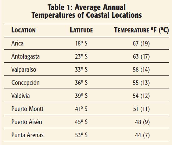
Chile's climates include a hot, parched desert—the Atacama—in the north, a Mediterranean climate in the middle, a marine (ocean-influenced) climate in the south, and a tundra (subpolar) climate in the extreme south. Temperatures decrease at increasingly higher latitudes (Table 1).
Chileans refer to the Atacama Desert as El Norte Grande (The Big North). A dry, subtropical, high-pressure air mass sits stubbornly over the area all year. As a result, the region receives less than 10 inches (250 millimeters) of precipitation. In the lowlands, precipitation only occurs in the summer (December through February) when rare, but occasionally fierce, thundershowers take place. The Atacama Desert is renowned as the world's driest desert. Arica has the world's lowest average annual precipitation, a scant 0.03 inches (0.762 millimeters).
Nearby Iquique holds the record for the number of uninterrupted years without even a trace of rain: 14. Enough winter snow falls in the peaks of the Andes to provide stream runoff for farming in isolated oases in the low desert. The streams, however, are ephemeral, meaning that they run for only short periods. After a rain, the water comes to a stop, evaporates, or seeps into the streambed and disappears. The Loa River is the only stream with a permanent flow. It is large enough to flow from the Andes across the desert to the ocean.
Chileans refer to the semiarid zone on the southern fringe of the Atacama Desert as El Norte Chico (The Little North). This zone is a transition from the arid desert to the more humid climates of central and southern Chile. A small amount of rainfall occurs in the winter, June through August, when leftovers of Pacific cyclonic storms arrive. Several small rivers (the Copiapo, Huasco, Elqui, Choapa, and Acongcagua) manage to meander to the seashore. The arrival of these storms is unreliable, so droughts occur every few years. Streams often dry up, much to the dismay of farmers and ranchers.
Middle Chile has a Mediterranean climate. This type of climate also exists around the shore of the Mediterranean Sea (hence the name) and in California, South Africa, and Australia. Mediterranean climates have mild, wet winters and dry summers. Chile's Mediterranean climate extends from the port city of Valparaiso, which is at the mouth of the Aconguaga River, to slightly south of the Bio Bio River. In winter, the edge of the same subtropical high-pressure air mass that dominates northern Chile shifts slightly north (toward the equator) and away from middle Chile. The winter shift allows eastwardmoving cyclonic storms from the Pacific to pass over the region. Because of mild temperatures, virtually all of the precipitation comes as rain. In summer, December through February, the edge of the high-pressure air mass shifts south (toward the pole), over middle Chile and slightly beyond to Puerto Montt. This shift forces the Pacific cyclonic storms farther south and causes a dry summer. Rare thunderstorms bring brief periods of relief to the dryness of summer. They also bring the threat of forest fires in the Andes from lightning strikes.
The coast range affects middle Chile's Mediterranean climate. It forms a barrier that blocks the cool summer breeze off the Pacific, making the summer temperatures on the coast cooler than those in the Central Valley. As a result, Santiago, which is in the valley, averages 16 days each summer with temperatures greater than 90 °F (32 °C), whereas Concepcion, on the coast, has never recorded a temperature in the nineties. The coast range also impedes moisture-bearing winter winds blowing from the ocean. As a result, there is a “rain shadow” of low precipitation in the Central Valley. The coastal areas receive about 40 to 50 inches (1,000 to 1,300 millimeters), whereas Santiago, located in the valley, receives only 11 inches (280 millimeters) annually.
The high elevations of middle Chile's central Andes are too wet and cold to have a Mediterranean climate. Because of the elevation, precipitation is greater than 100 inches (2,500 millimeters) in some places, and it comes mainly in the form of snow. In fact, transportation routes through the mountain passes are typically closed in the winter due to heavy snowstorms. The only all-season route to Argentina is the Los Libertadores (The Liberators) tunnel northeast of Santiago. As previously mentioned, snowfall above about 8,000 feet (3,500 meters) is sufficient to support the existence of glaciers in this part of the Andes.
Southern Chile has a marine (ocean-influenced) climate. Precipitation from Pacific cyclonic storms occurs there year-round. The storms form as a cold polar and warm tropical air mix and spiral violently upward over the Pacific Ocean.
Southern Chile is cool and wet as the storms pass over land. In the north end of southern Chile, temperatures are mildest in part because of the moderating influence of the ocean. The seaport of Puerto Montt represents the north-end climate. The city has an average annual temperature of 51 °F (10 °C) and an annual precipitation level of 86 inches (2,184 millimeters).
Precipitation totals in southern Chile vary greatly from place to place. The coastal islands have some of the heaviest precipitation in South America. The cloud-shrouded islands of Madre de Dios (Mother of God) and Wellington receive about 275 inches (7000 millimeters). The western side of the Andes gets more than 120 inches (2,500 millimeters), which is more typical for the region. In stark contrast, the eastern side is in a rain shadow and gets less than 20 inches (500 millimeters) in some places.
In the extreme south (which includes the Patagonian Andes and Tierra del Fuego), short winter days and low sun angles keep temperatures low. Pacific Ocean waters of the frigid Antarctic Current and cold Humboldt Current cut temperatures more. Fierce winds make the temperatures feel even colder. Despite relatively low elevations, snow from frequent cyclonic storms creates massive ice fields in the Patagonian Andes. In contrast, on the island of Tierra del Fuego, a rain shadow cuts precipitation to a drizzle. Here, moisture often hangs in the air as a drippy fog. Punta Arenas, the main settlement in the extreme south, receives only 16 inches (406 millimeters) of precipitation, but the dampness of clouds and fog is everywhere. The average annual temperature is just 44 °F (7 °C).
The cold Humboldt Current plays an important role in the climate of coastal Chile. The current is born as it splits from the eastward-traveling Antarctic Current and turns north to pass next to Chile. The Humboldt warms up as it flows toward the equator, but it remains cool enough to affect summer temperatures along the coasts of middle and northern Chile. As subtropical heat is drawn into the cold current, air temperatures decrease and a soupy fog forms offshore. The fog is so thick that Chileans and Peruvians call it a garua, which means “drizzle” in Spanish. A sea breeze blows the cool air and the garua onshore, bringing relief from summer temperatures there. This moderating effect does not extend inland; the coast range blocks the cool sea breeze and gartia, except where there are valley openings. The resulting difference between inland and coastal temperatures in the summer is noteworthy. For example, daytime temperatures in January in inland Santiago average 85 °F (29 °C), whereas in coastal Concepcion, they average 71° F (22 °C). As we will see, the cold Humboldt Current's affect on summer temperatures is significant enough to affect patterns of natural vegetation and agriculture in the country.
PLANTS AND SOILS
In northern Chile, plant life is sparse because of poor soils, desert dryness, and harsh temperatures. A few species of grass survive the scarcity of soil moisture by growing in bunches. The grasses provide some forage for grazing cattle, sheep, mules, llamas, and other camel-like livestock. A few cacti species also survive the desert conditions. The lowest part of the basin floors is barren because the soil is too salty for plants to grow. Between the basin floors and the bases of alluvial fans, the tamarugo tree once covered hundreds of square miles. The tree grew to a height of 80 feet (25 meters), and its deep roots reached the Andean groundwater below.
The tamarugo is almost extinct now. The abundance of such a tall tree in a desert must have been a fantastic scene for early inhabitants and explorers of the region. By the beginning of the twentieth century, most of the tamarugo trees had been cut down and the wood used for fuel in foundries that processed copper and sodium nitrate. Trees were also lost because ranchers allowed sheep and cattle to eat the pulpy seedpods. As a result, the tamarugo was unable to reproduce in large numbers.
Northern Chile has two other interesting plants. The green, resinous, fragrant tola bush grows wherever Andean groundwater seeps to the surface. In mountain canyons, there are small groves of the quenoa tree. The tree can be 10 to 13 feet (3 to 4 meters) in height. Its trunk and branches appear dry and twisted, but its tiny leaves conserve moisture.
The Mediterranean climate in middle Chile is much better than the desert for plant growth and soil development. The soils are deep and fertile in the Central Valley. Andean streams have added alluvium and, volcanic eruptions have added layers of mineral-rich ash. In order to take advantage of the soil fertility, Chileans have removed natural vegetation from the valley floor and Andean foothills to grow crops and graze animals. On steeper slopes in the foothills, where farming is too difficult, a mixture of shrubs and oak and pine trees still thrives. Ascending into the main part of the Andes, decreasing temperatures limit plant growth. Only pine trees do well there. At 8,000 feet (2,400 meters), temperatures are so cold that only a few scraggly pines, widely spaced shrubs, and bunch grasses survive. Above 8,000 feet (2,400 meters), only mosses, lichens, and annual flowering plants can cling to life.
In southern Chile, a dense mid-latitude rain forest, composed of broadleaf, evergreen species, covers the area's islands and lower mountain slopes. This rain forest has fewer trees and less dense growth of underbrush compared to the tropical rain forest. In small areas of scattered, mixed woodlands, two unique trees appear together here and in neighboring areas of Argentina. The first is the deciduous southern beech. The second is the evergreen araucaria pine. The araucaria's nuts are a traditional dietary staple of Indians in this part of South America. Both trees are harvested for their timber today.
FAUNA
Fauna (animal life) also varies from north to south. The list of interesting mammals is endless, including many fur-bearing animals that are endangered because of a long history of over-hunting. In the northern Andes are all four members of the South American camelid family: the llama, alpaca, vicufta, and guanaco. These camel-like animals are hard to tell apart. The llama and alpaca are longhaired and valued for their wool. For that reason, they are tamed and held in corrals most of the time.
The large huemul deer, like the four camelids, graze in herds. The huemul is found in many different habitats of Chile, but it is an endangered species because of overhunting. This handsome deer appears on the Chilean coat of arms. The southern forests shelter the Darwin fox, another endangered species. The tiny pudii, which is the world's smallest deer and another endangered species, survives on Chiloe Island and a nearby island. Chile also has several kinds of marsupials, or animals with pouches like that of a kangaroo or opossum.
Elusive Andean wolves, wildcats, and pumas prey on all these animals. The vizcacha is also an Andean dweller. It looks like a large rabbit, but it is a rodent and a relative of the Chilean guinea pig and chinchilla, which are also Andean inhabitants. Coastal areas teem with all kinds of bird life: seagulls, pelicans, petrels, and penguins. Sea swallows and cormorants are also abundant. Inland, Chilean flamingos busy themselves by probing the mud of altiplano lakes for snails and bugs in winter. Like brush strokes of pink, they streak across the sky on their way to southern Chile in the summer. Other inland birds—swallows, woodpeckers, hummingbirds, doves, and ducks—occupy the many niches of Chile's crazy-quilt geography. The giant Andean condor, Chile's national bird, occasionally is seen in the mountains. In Tierra del Fuego, this vulture preys on the sheep population. Chile also has penguins. This flightless bird lives in scattered coastal colonies.
Each colony has several thousand members. Most penguins spend the entire year in southern Chile, but in winter, some of them ride the Humboldt Current as far as northern Chile. There are few species of freshwater fishes natural to Chile. The lake trout, introduced from North America, is plentiful and reaches sizes of 30 inches (76.2 centimeters) or more. A wide variety of ocean fish abound in the cool coastal waters. Chile is one of the world's largest fish exporters because of the large marine fish population. Big game fishing for marlin and swordfish is excellent near Tocopilla, north of Antofagasta. Tuna and anchovies thrive along most of the coast.
Marine mammals increase in number farther south. In the cool Humboldt Current, sea otters, seals, and sea lions are near the top of the food chain. They feed on an abundant supply of fish, shellfish, and squid. Further offshore, dolphins feed on small fish. Higher on the food chain, orcas (killer whales) feed on the sea otters, seals, sea lions, and dolphins. Whales also frequent Chile's waters. Early whale hunters almost killed these magnificent mammals off for their oily blubber. The oil in the blubber lit many a lantern in the nineteenth century.
In the twentieth century, whale oil became more important as a lubricant and as an ingredient in cosmetics, among other things. Some whales, such as the minke, also became favored for their meat. Blue whales are probably the most prominent (and most interesting) in Chilean waters. They are now protected from overhunting. They have unique baleen plates instead of teeth. They troll the water with their mouths open and use the plates to filter out zooplankton (microscopic animals) for their food.
FOREST AND WILDLIFE PROTECTION
Chile has some beautiful wilderness areas where laws protect wildlife and vegetation. Wilderness areas are also remote areas, and as a result, humans sneak into these areas to cut valuable trees for timber and to hunt wild animals, such as the huemul. The huemul and several other species of land mammals are prized for their meat and hides. Because of poaching, such animals are on the verge of extinction. Almost one-fifth of Chile is protected to varying degrees in national parks and reserves.
Chile's diverse physical geography means that its national treasures are extremely varied. The national forestry commission administers 32 national parks, 47 national reserves, and 13 natural monuments. Chileans are making efforts to preserve their forests and wildlife, because they realize that plants and animals are important resources for the future.