Temperature and Precipitation Regimes
Many parts of the world show distinctive patterns of monthly temperature and precipitation, usually related to latitude and location. These patterns are referred to as regimes of temperature and precipitation.
TEMPERATURE REGIMES
Figure 7.5 shows annual cycles of air temperature for different temperature regimes. The equatorial regime (Douala, Cameroon, 4° N) is uniformly very warm, with temperatures close to 27°C (81°F) year round because insolation is nearly uniform throughout the year. In contrast, temperatures in the tropical continental regime (In Salah, Algeria, 27° N) change from very hot, when the Sun is high in the sky near a solstice, to mild, when the Sun is lower at the opposite solstice.
The tropical west-coast regime at Walvis Bay, Namibia (23° S)—nearly the same latitude as In Salah—has only a weak annual cycle and no extreme heat because of the moderating effects of its maritime location. This moderating effect persists poleward into the midlatitude west-coast regime—Monterey, California (36° N) and Sitka, Alaska (57° N). In continental interiors, however, the midlatitude continental regime of Omaha, Nebraska (41° N), and the subarctic continental regime of Fort Vermilion, Alberta (58° N), show large annual variations in mean monthly temperature of about 30°C (54°F) and 40°C (72°F), respectively. The ice sheet regime of Greenland (Eismitte, 71° N) experiences severe cold all year.
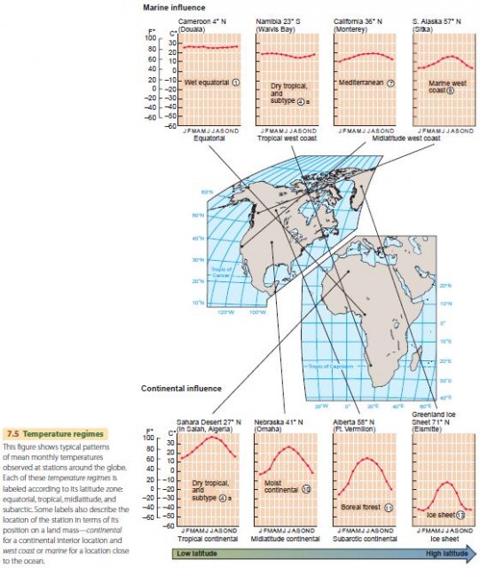
Overall, we find that (1) annual variation in insolation, determined by latitude, provides the basic control on temperature, and (2) the effect of location—maritime or continental—moderates that variation.
Another factor affecting air temperature is elevation. High-elevation stations show cooler temperatures than sealevel stations. Temperatures are cooler because the atmosphere cools with elevation at the average environmental temperature lapse rate of 6.4°C/1000 m (3.5° F/1000 ft).
GLOBAL PRECIPITATION PATTERNS
Global precipitation patterns are largely determined by air masses and their movements, which in turn are produced by global air circulation patterns. Before taking a detailed look at global precipitation patterns, let's look at Figure 7.6, which shows the general patterns expected for a hypothetical supercontinent that has most of the features of the Earth's continents but is simplified. The map recognizes and defines five classes of annual precipitation: wet, humid, subhumid, semiarid, and arid.
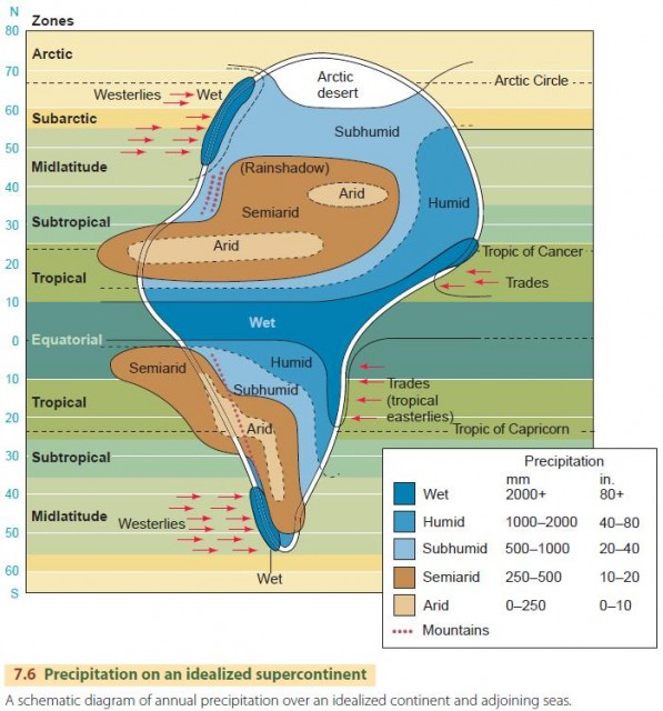
Beginning with the equatorial zone, the figure shows a wet band stretching across the continent. This band is produced by convective precipitation over the equatorial lows near the intertropical convergence zone. Note that the wet band widens and is extended poleward into the tropical zone along the continent's eastern coasts. This region is kept moist by the influence of the trade winds, which move warm, moist mT air masses and tropical cyclones westward onto the continental coast.
Farther poleward, humid conditions continue along the east coasts into the midlatitude zones. In these regions, subtropical high-pressure cells tend to move mT air masses from the southeast onto the continent in the summer, whereas in winter, midlatitude cyclones bring cyclonic precipitation from the west.
In the arctic zone, shown on the continent as arctic desert, precipitation remains low because air temperatures are low, and only a small amount of moisture is contained in cold air.
Another important feature of the hypothetical continent is the pattern of arid and semiarid regimes that stretches from tropical west coasts to subtropical and midlatitude continental interiors. In the tropical and subtropical latitudes, the arid pattern is produced by dry, subsiding air in persistent subtropical high-pressure cells. The aridity continues eastward and poleward into semiarid continental interiors, which remain relatively dry because they are far from source regions for moist air masses. Rainshadow effects provided by coastal mountain barriers are also important in maintaining inland aridity.
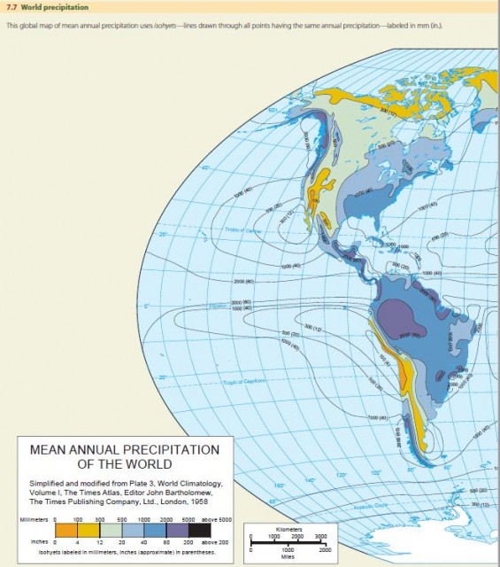
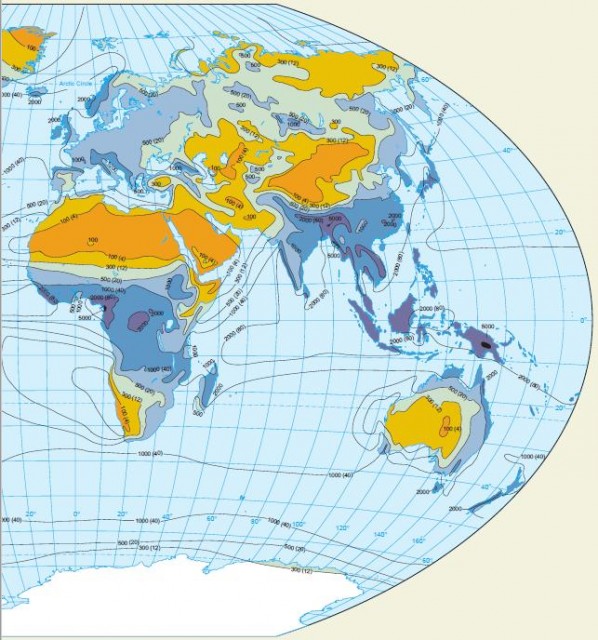
Yet another obvious feature of the supercontinent is the pair of wet bands along the west coasts of the midlatitude and subarctic zones. These are produced by the eastward movement of moist mP air masses onto the continent, as driven by the prevailing westerlies. These features of the supercontinent are echoed in the actual pattern of global precipitation, shown in Figure 7.7. This map of mean annual precipitation shows isohyets—lines drawn through all points having the same annual precipitation. Using the same logic that we used to explain the precipitation patterns of the hypothetical continent, we can recognize seven global precipitation regions as follows:
- Wet equatorial belt. This zone of heavy rainfall, over 2000 mm (80 in.) annually, straddles the Equator and includes the Amazon River Basin in South America, the Congo River Basin of equatorial Africa, much of the African coast from Nigeria west to Guinea, and the East Indies. In this zone, the warm temperatures and high-moisture content of the mE air masses favor abundant convective rainfall.
- Trade-wind coasts. Narrow coastal belts of high rainfall, 1500 to 2000 mm (about 60 to 80 in.), extend from near the Equator to latitudes of about 25° to 30° N and S on the eastern sides of every continent or large island. Examples include the eastern coast of Brazil, Central America, Madagascar, and northeastern Australia. The rainfall of these coasts is supplied by moist mT air masses from warm oceans that are brought over the land by the trade winds and encounter coastal hills and mountains, producing heavy orographic rainfall.
- Tropical deserts. In contrast to the wet equatorial belt are the zones of tropical deserts lying approximately on the Tropics of Cancer and Capricorn. These are hot, barren deserts with less than 250 mm (10 in.) of rainfall annually and, in many places, with less than 50 mm (2 in.). They are located under the large, stationary subtropical cells of high pressure, in which the subsiding cT air mass is adiabatically warmed and dried.
- Midlatitude deserts and steppes. Farther northward, in the interiors of Asia and North America between latitude 30° and latitude 50°, are great deserts, as well as vast expanses of semiarid grasslands known as steppes. Annual precipitation ranges from less than 100 mm (4 in.) in the driest areas to 500 mm (20 in.) in the moister steppes. Located in regions of prevailing westerly winds, these arid lands are far from sources of oceanic moisture and typically lie in rain shadows on the lee side of coastal mountains and highlands. In the southern hemisphere, the dry steppes of Patagonia, lying on the lee side of the Andean chain, are roughly the counterpart of the North American deserts and steppes.
- Moist subtropical regions. On the southeastern sides of the continents of North America and Asia, in latitude 25° to 45° N, are the moist subtropical regions, with 1000 to 1500 mm (about 40 to 60 in.) of rainfall annually. Smaller areas of the same type are found in Uruguay, Argentina, and
southeastern Australia. These regions are positioned on the moist western sides of the oceanic subtropical high-pressure circulations, which bring moist mT air masses from the tropical ocean onto the continent. - Midlatitude west coasts. Another wet location is on midlatitude west coasts of all continents and large islands lying between latitudes about 35° and 65° in the region of prevailing westerly winds. In these zones, abundant orographic precipitation occurs as a result of forced uplift of mP air masses. Where the coasts are mountainous, as in British Columbia, southern Chile, Scotland, and South Island of New Zealand, the annual precipitation is over 2000 mm (79 in.).
- Arctic and polar deserts. A seventh precipitation region is formed by the arctic and polar deserts. Northward of the 60th parallel, annual precipitation is largely under 300 mm (12 in.), except for the west-coast belts. Cold cP and cA air masses cannot contain much moisture, and, consequently, they do not yield large amounts of precipitation.
PRECIPITATION REGIMES
Total annual precipitation is a useful quantity in establishing the character of a climate type, but it does not account for the seasonality of precipitation. The variation in monthly precipitation through the annual cycle is a very important factor in climate descriptions. If there is a pattern of alternating dry and wet seasons instead of a uniform distribution of precipitation throughout the year, we can expect that the natural vegetation, soils, crops, and human use of the land will all be different. It also makes a difference whether the wet season coincides with a season of higher temperatures or with a season of lower temperatures. If the warm season is also wet, growth of both native plants and crops is enhanced.
If the warm season is dry, the stress on growing plants is great, and irrigation is required for most crops. Monthly precipitation patterns can be grouped into three types: (1) uniformly distributed precipitation; (2) a precipitation maximum during the summer (or season of high Sun), in which insolation is higher; and (3) a precipitation maximum during the winter or cooler season (season of low Sun), when daily insolation is lower. Note that the uniform pattern can include a wide range of possibilities from little or no precipitation in any month to abundant precipitation in all months.
Figure 7.8 shows a set of monthly precipitation diagrams selected to illustrate the major types that occur over the globe. Two stations show the uniformly distributed pattern described above—Singapore, a wet equatorial station near the Equator (1?° N), and Tamanrasset, Algeria, a tropical desert station very near the Tropic of Cancer at 23° N.
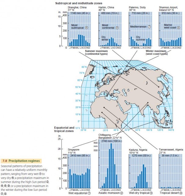
In Singapore, rainfall is abundant in all months, but some months have somewhat more rain than others. Tamanrasset has so little rain in any month that it scarcely shows on the graph.
Chittagong, Bangladesh (22?° N), and Kaduna, Nigeria (10?° N), both show patterns of the second type—that is, a wet season at the time of high Sun (summer solstice) and a dry season at the time of low Sun (winter solstice). Chittagong is an Asian monsoon station, with a very large amount of precipitation falling during the high-Sun season. Kaduna, an African station with about half as much annual precipitation, shows a similar pattern and is also of the wet-dry tropical type. Both stations experience their wet season when the intertropical convergence zone (ITCZ) is nearby and their dry season when the ITCZ has retreated to the other hemisphere.
The summer precipitation maximum also occurs at higher latitudes on the eastern sides of continents. Shanghai, China (31° N), shows this pattern nicely in the subtropical zone. The same summer maximum persists into the midlatitudes. For example, Harbin, in eastern China (46° N), has a long, dry winter with a marked period of summer rain.
In contrast to these patterns are cycles with a winter precipitation maximum. Palermo, Sicily (38° N), is an example of this Mediterranean type of climate, named for its prevalence in the lands surrounding the Mediterranean Sea. This type experiences a very dry summer but has a moist winter. Southern and central California are also regions of this climate type.
In Mediterranean climates, summer drought is produced by subtropical high-pressure cells, which intensify and move poleward during the high-Sun season. These cells extend into the regions of Mediterranean climate, providing the hot, dry weather associated with cT air masses while blocking the passage of moister air masses from the oceans. In the low-Sun season, the subtropical high-pressure cells move equatorward and weaken, allowing frontal and cyclonic precipitation to penetrate into Mediterranean climate regions.
The dry-summer, moist-winter cycle is carried into the higher midlatitudes along narrow strips of west coasts. Shannon Airport, Ireland (53° N), has this marine westcoast type of climate, although the difference between summer and winter rainfall is not as marked. Summers at Shannon Airport have less rainfall for two reasons. First, the blocking effects of subtropical high-pressure cells tend to extend poleward into the region, keeping moister air masses and cyclonic storms away. Second, the cyclonic storms that produce much of the winter precipitation are reduced in intensity during the high-Sun season because the temperature and moisture contrasts between polar and arctic air masses and tropical air masses are weaker in summer. The weaker contrasts are caused by increased high-latitude insolation. Without the strong temperature contrast, disturbances in the jet stream do not tend to grow as large, so neither do the underlying midlatitude cyclones.