Where Are Thunderstorms Most Common?
THUNDERSTORMS CAN OCCUR as isolated single-cell thunderstorms, forming over mountains and other local features, or can be embedded in larger weather systems, like mid-latitude cyclones or multi-cell thunderstorms. By knowing how thunderstorms form, can you predict where they should be most common?
How Does Thunderstorm Frequency Vary Globally?
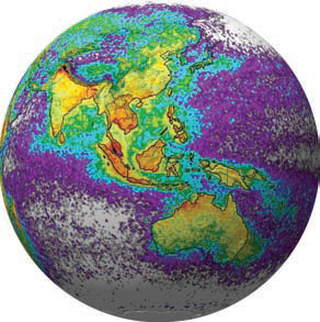
Space-based detections of lightning can be used to determine the global distribution of thunderstorms. Optical sensors on satellites use high-speed cameras to look into the tops of clouds that the human eye cannot detect. Observe the map below, which shows the average yearly counts of lightning flashes per square kilometer based on data collected by NASA satellites.
1. These data were collected between 1995 and 2002. Places where fewer than one flash occurred (on average) each year are gray or purple. Places with moderate numbers of flashes are green and yellow, and places with the highest frequency of lightning strikes are red or black. Observe the main patterns before you read the associated text.
2. The globes show that lightning strikes are much more common on land than over the oceans. Large landmasses can heat up during the day and cause free convection, resulting in thunderstorms. Above the oceans, thunderstorms are more frequent near coastlines than in areas far from a coast; this reflects the sharp contrasts in air masses that occur along coastlines.
3. Most of the 2,000 or so thunderstorms occurring at any time in the world are located within the Intertropical Convergence Zone (ITCZ), especially in the afternoon. Abundant tropical moisture, strong surface heating, and vigorous trade-wind convergence are responsible. Note the high density of thunderstorms in central Africa, attributable to the ITCZ and a large continent. ITCZ-related thunderstorms are also abundant in southern Central America, Southeast Asia, and Indonesia (northwest of Australia).
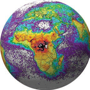
4. North America exhibits frequent thunderstorms, reflecting a supply of warm, moist air from the Gulf of Mexico, abundant solar heating of the land, and the frequent passages of weather fronts. Europe commonly lacks much contrast between air masses, as the westerlies push a continual parade of mP air masses across the continent. Also, the mountains mostly trend east-west, parallel to the westerlies, minimizing the interaction between very hot and very cold air masses. As a result, Europe has fewer thunderstorms than might be expected, considering the frequency of frontal passages and rainy days.
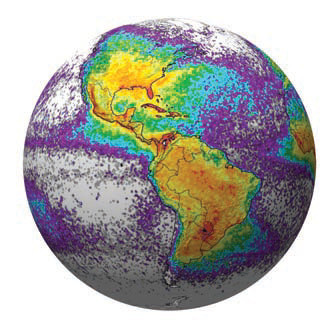
5. Polar regions, including Antarctica, are too cold to have moisture sufficient for the condensation and deposition required to support thunderstorms, even in the summer. Both poles are among the places least likely to experience thunderstorms and lightning.
Seasonal Variations
6. These maps show the variations in lightning (thunderstorms) between summer and winter. The top map is for winter in the Northern Hemisphere and summer in the Southern Hemisphere. The bottom map shows the opposite (northern summer; southern winter). Examine these maps and compare the number of thunderstorms in summer versus winter for different regions.
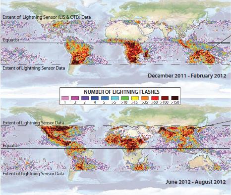
7. From December through February, there are many more thunderstorms south of the equator than north of it. Note, for example, the difference in Australia and Southeast Asia between the two maps. During this time, thunderstorms are also abundant in southern Africa and in South America.
8. During June through August, the locus of thunderstorm activity shifts to the Northern Hemisphere, where it is summer. The difference in thunderstorm activity between the two maps is especially noticeable in North America and Central America. Thunderstorms in mainland Asia are tied closely to the summer monsoon, when surface heating combines with moist onshore flow to create strong convection. Central Africa, straddling the equator, reports thunderstorms during both seasons. Sinking air in the descending limb of the Hadley cell, combined with limited moisture, suppresses the development of thunderstorms in the Sahara and Arabian Deserts.
How Does Thunderstorm Frequency Vary Throughout the Continental U.S.?
1. This map shows the frequency of thunderstorms in different parts of the U.S., as expressed by the number of days per year that an area has thunderstorms.
2. Few thunderstorms occur on the Pacific Coast, even though there are many rainy days. Surface heating is seldom strong enough to create free convection. The difference between air masses across frontal boundaries is too slight to generate vigorous uplift. Cold air masses are not bitterly cold, and warm air masses are not too hot due to the moderating influence of the Pacific Ocean. Orographic uplift can generate an occasional thunderstorm, but even these are not too frequent as most of the coastal ranges are not very high and the highest ones are farther north, next to cold
ocean waters.
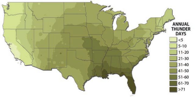
3. Thunderstorms are somewhat more common elsewhere in the West, even though moisture is relatively scarce. More thunderstorms occur on the peaks of the highest mountains, where surface daytime heating moves air upslope from all sides, converging at the peaks and forcing additional uplift.
4. In the Midwest and Northeast, thunderstorms increase in frequency from north to south. Water-vapor capacities in the northern states are so low most of the year that they limit the supply of atmospheric moisture available for release as latent heat during condensation, which is essential to generate severe storms.
5. The Southeast has the highest frequency of thunderstorms in the U.S., with the Florida peninsula experiencing the most thunderstorms in the country. Winter and early spring thunderstorms mostly originate from cold fronts trailing from Gulf Lows and Colorado Lows. Spring, summer, and, to some extent, fall thunderstorms occur because of convective afternoon thunderstorms in an unstable atmosphere. When the surface heats up and air rises, a “double sea breeze” causes onshore flow from both the Gulf of Mexico and the Atlantic to fill in the low pressure over Florida. Late summer and fall also bring tropical cyclone-induced thunderstorms. The region has a combination of warm seawater, warm air, a sea-land contrast, and a position near storm tracks.
Seasonal Variations
These maps show the frequency of thunderstorms for different months. In March and April, thunderstorms occur inland along the Lower Mississippi Valley because cold and warm air masses come into contact with each other at strong cold fronts, accompanied by moisture from the Gulf of Mexico.
During May, the peak in Texas results from the combination of early summer convection on some days with late season cold-front activity on others.
In June, the location of thunderstorm activity shifts farther north and inland, onto the Great Plains. Land surfaces are starting to warm up, but cold air is nearby in Canada and sometimes flows into the plains. Cyclonic activity enhances the likelihood of thunderstorms in the central U.S. Thunderstorm activity begins to pick up in Florida, with the arrival of summer.
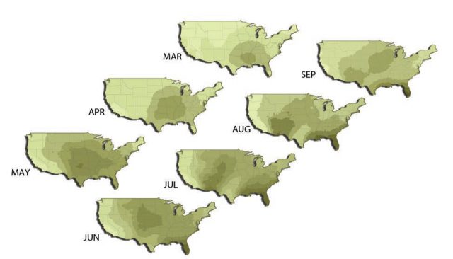
The September peak in Florida is the result of tropical cyclones enhancing the convectional thunderstorm activity. Hurricane season peaks in August and September. The rest of the southeastern U.S. has the same ingredients for thunderstorm formation as Florida, except for the “double sea breeze.”
Most of the U.S. sees a summer peak in thunderstorm days, so activity picks up in July and August. By July, surface heating allows for destabilization of the atmosphere during afternoon hours. Summer cold fronts supplement these convectional thunderstorms in the Northeast and north-central states, while tropical cyclones (of strengths varying from tropical waves to hurricanes) can add to the frequency of thunderstorms in the Southeast. Increased thunderstorm activity in the Southwest and intermountain states of the West largely reflects the onset of the Arizona monsoon.